Users can set preferences for how their sonar logs are
initially processed—such as depth offsets, sonar channel selection for vegetation mapping, buffer extent, and more. The default settings
are robust and optimized based on extensive user experience, ensuring that novice users can generate high-quality map outputs without
needing to make adjustments. However, because survey conditions and user approaches can vary widely, advanced users may choose to
fine-tune these settings to achieve the most accurate and useful results.
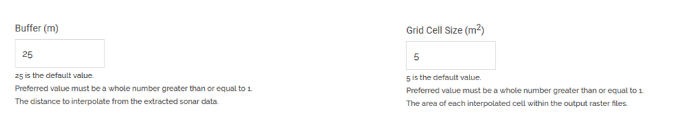
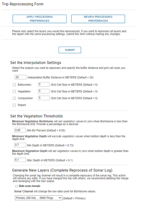
Buffer and Grid Cell
Select a buffer that controls how much of the map output is
interpolated or extrapolated. Select the grid cell (minimum mapping unit) that
defines the minimum resolution of any particular point on the map. If you are
mapping small ponds with dense transect spacing, 1m grid cells are appropriate.
Mapping large lakes with wide transects, consider larger grid cells and buffers.
Note: Buffer settings
are always in metric. Prior to deviating from the default 25-m buffer and 5-m
grid cells, we recommend users consult this blog or other hydrographic mapping
resources about best mapping/interpolation practices.
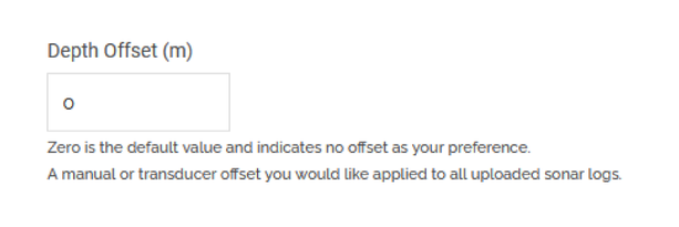
Depth Offset
Insert an offset that will be added (positive number) or
subtracted (negative number) from individual depth measurements for every uploaded
trip automatically. Vegetation height will be lowered if the new depth is shallower
than the vegetation but vegetation height (e.g., negative depth offset) will not be
lengthened if a positive offset is put in place. This setting will be used most
often for users who have a transducer that is a fixed depth below the surface.
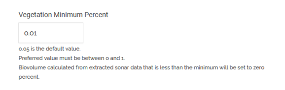
Vegetation Biovolume Detection Threshold
This setting controls the minimum length of a plant (expressed in
biovolume as a decimal) that could be detected by EcoSound algorithms. Note that in
deeper waters 1% represents taller plants than shallow waters. This setting is an
important control against bottom debris erroneously being detected as vegetation.
Often the algorithms do not know what is debris and what is vegetation. Now, users
can control this setting. EcoSound processing will set the final vegetation
coordinate value to zero for points where vegetation is preliminarily determined to
be less than this amount.
Note: Interpolation
can generate smaller values than the minimum detection threshold because it
makes predictions on a neighborhood of values (e.g., 5% bv surrounded by 0%
bv will result in values less than 5% for a grid cell even if the user
setting is 0.05).
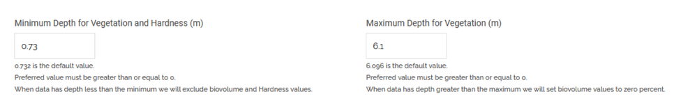
Minimum and Maximum Depth for Vegetation
As the depth gets shallow (e.g., less than 1 m), the target
separation between the transducer and the bottom becomes quite narrow and difficult
for the algorithms to confidently separate noise from bottom and plant
characteristics in these high energy environments. Users can set the depth at which
any vegetation or bottom hardness points shallower will automatically be discarded.
In contrast, in deep areas, sometimes thermoclines or insect emergence can be
mistaken for deep growing vegetation. As such, users can now set a maximum depth of
plant detection whereby any points that are interpreted as vegetation deeper than
this threshold will be converted to biovolume values equal to zero.
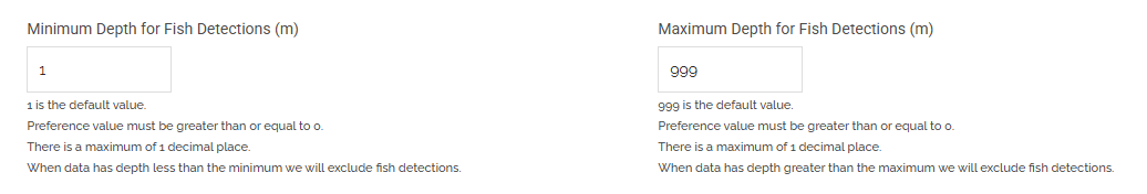
Minimum and Maximum Depth for Fish Detections
You can set depth limits for fish detections to reduce false positives and focus on counts within specific depth ranges.
False detections can occur near the surface due to floating vegetation or debris, interference from structures attached
to or dangling off the hull, or turbulence at the surface that introduces air bubbles. Setting deeper depth limits can
also help highlight certain species. While EcoFish does not identify species, combining these depth settings with general
habitat knowledge can give you a good idea of which species are likely present.
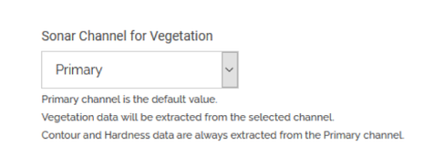
Preferred Sonar Channel Type
Users can select the option to process either the downscan (455 or
800 kHz) channel or primary (200 kHz) for vegetation (the previous EcoSound only
processed 200 kHz Primary). Both channels have performed well in preliminary tests
but the outcomes appear highly dependent on local conditions (depth, water clarity,
vegetation type and density). We recommend users run their own tests to determine
which one performs best for the environments in which they are working.
Generate Sonar Imagery
Overlay
Enables overlay dots that delineate bottom data points and plant canopy data points
on the top of the sonar imagery.
Note: The dot overlay cannot be recreated
after the fact by the user. Use the Ask the Experts button in the trip viewer to
request a trip be reprocessed from scratch to generate the dot overlay on a trip
already processed.
Generate Side-Scan Mosaic Layer
For Habitat+ plans, users who have transducers with SideScan can process SideScan
imagery and create a mosaic layer.
Generate EcoFish Outputs
With an EcoFish subscription, you can choose to enable or disable EcoFish outputs in two places: here on the Processing
Preferences page and during the trip upload process. Disabling this option will help reduce the processing time of your
trips.
Apply global settings or customize settings on an individual basis
Users also have the ability to apply these global settings or
customize their settings on an individual basis for a specific trip or merge of
interest.
Note: Reprocessing of
the raw sonar log is required if a different sonar channel is selected or if
you want to process SideScan for a trip that does not have it. You must have
the appropriate subscription and transducer to do this. After 90 days of the
upload date, sonar logs are archived and the ability to reprocess with a
different sonar channel is no longer available to the end user. Contact
BioBase support if you have special reprocessing requests